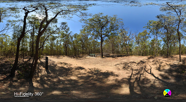
This is the bush that I grew up with. As a kid, my parents' house backed onto a private allotment of undeveloped scrub that joined the bush along Creek and Richmond roads. Most of that parcel of land was developed long ago though remnants remain, like the Rembrandt Street Park which follows the flow of Todman Street Creek - as we called it - that flows into the Minnippi wetlands. There is still a small section of bush that goes through to Richmond road though my closest access point is D'arcy Road, where my parents still live today. Back in the 1970s, we would occasionally ride our bikes along the gulley trails that seemed to have been there forever. The hills are very steep so we didn't often bother trying to go up them! There were some fire roads too, though I don't recall them being so distinct or extensive as they are now.
 |
| The bush began at the property line of our backyard. |
In the 1990s the remaining 50+ hectares of land which had not been released for development, was declared a Reserve by the Brisbane City Council. The future of this near-city parkland has been looking up ever since. In 2006 I took up documenting this rapidly changing area I grew up in, whenever I was visiting. Mostly by photographing Post War homes - on treeless blocks under an open sky, that remained as I remembered them walking to and from school. Then in 2019, having started shooting 360-degree panoramas the year before, I decided to see how an environment as visually busy as the bush would work, it looked like a challenge worth trying.
 |
| Peak Ridge, the Highest Point - Seven Hills Bush Reserve |
The first series of shots were made toward the end of a long dry spell in September 2019. The second set is after a drought-breaking storm on the 12th of December of the same year. This clearly shows the impact of the massive flow of water - and debris through the previously dry gullies which are now a series of ponds or billabongs, where I saw kids catch yabbies in my youth.
 |
| In the gully after heavy rain - 360° Panorama |
In 2021 I was back for an extended stay to help out with family matters and took to going for morning or evening walks in the reserve a bit like a born-again-local! I decided to try out all the trails I could find which eventually lead me to the other side of Peak Ridge and The Promenade down to Perrin Creek, which is an area I had never explored before.
 |
| Uranus Avenue & Tiburtina Crescent looking toward Latina Ave Trail Head |
There are a lot of unusual names for Australian streets and hills, in Seven Hills, though it was only after looking at a topographic map of the area after making these 360s that I began to see why. The Hills and many streets take their names from the seven hills of Rome, as in Rome, Italy. Palatine Hill, Capitoline Hill, Quirinal Hill, Aventine Hill, Caelian Hill, Viminal Hill and Esquiline Hill, which locals call the Promenade after the steep street that in typical Brisbane style simply runs straight up it!
 |
| Seven Hills Circuit at Perrin Creek - 360° Panorama |
Perhaps a little ironically, only Esquiline Hill is part of the reserve with the hills inside the park being Peak Ridge at 68 meters and Days Hill at 47, the cardio stars of The Seven Hills Circuit walking track. Back towards Richmond Road, there are more European street names with Brussels, Britannia and Paris Avenues - I wish I had known how international we were out here in Brisbane suburbia when growing up.
'Kent have you ever been to Paris?'
'Sure, we used to ride our bikes there as kids!'
 |
| On the banks of Perrin Creek - 360° Panorama |
The two 'tours' I created are an attempt to show some of my key places within the reserve and a variety of conditions, from dry to damp and the variety of trees and scrub, and I hope to share the feeling I experience when simply walking along looking up into the trees, down into the gullies and along the banks of a creek or trail. There is plenty of birdlife, insect life, possibly Koalas (though I've never seen one - I've met people who say they have) lizards, water dragons, snakes, possums, and other walkers with dogs (on leads please) and runners. Even riders on horses - though banned.
 |
| Paperbarks near Perrin Creek near Phalerum Ave in 360° |
Seven Hills Bush Reserve is a much more diverse and interesting area than I ever realised. The air is fresh. There are views of the city and the thin sticky trees I didn't think much of as a kid, I now think of as unique! And there are a lot of other trees there too, large and small, and as volunteers and rangers keep working, it looks like the reserve will continue to have a lot to offer for a long time to come.